Driving the Apache Trail was high on our list of must-do Arizona activities. This twisty hairpin road, billed as “best scenic drive in Arizona” was originally a stagecoach route called the Tonto Wagon Trail. You tend to think of things like stagecoaches when you’re in southern Arizona; it is a state that straddles the past and the present. I’m trying to imagine the fortitude required to be on a stagecoach under any circumstances, but bumping along over a narrow rutted mountain road, roasting in my muslin dress and bonnet, hanging on to a child or two and hoping those spindly wooden wagon wheels are up to the task is beyond my scope.
We were lucky to find a campsite at the very popular Lost Dutchman State Park near Apache Junction; a last-minute cancellation of 4 nights that we gratefully snapped up. Our preferred method of travel – poke along as we like, with detours along the way – does not work well in most parts of the United States and probably not in Canada, either. Campsites in state and national parks are booked months in advance and unless you are willing to play the last-minute game, hoping for cancellations – you are out of luck.
We scored a beautiful spot, with a view of Superstition Mountain.

Lost Dutchman State Park is filled with hiking trails, but unfortunately for us, weather was not on our side. We had a day and a half of significant rainfall and high winds, so we fit in short walks between rain and dug in with our books.
One night there was a forecast of thunderstorms, but aside from a few half-hearted claps, that never materialized. I LOVE a good thunderstorm; something that is quite rare on the west coast.

Apache Junction has a number of wild west tourist attractions, including a reconstructed ghost town, which did not appeal to us.
We saw this sign on a restaurant called The Hitching Post, not far from our campground. At first I thought it was a cheeky anti-Wall statement, but now I’m not so sure – it’s up to interpretation.

So, back to our reason for being here – The Apache Trail. On our last day, the rain had finally stopped and it dawned clear and bright. Since we were warned there were a number of washes and dips on the road that were subject to flash floods, we wondered if we might encounter difficulties. The ranger seemed concerned; with a scrunched-up face and a worried comment about cars floating if there was more than four inches of water on the tires, we weren’t reassured. She also wondered about the state of the dirt road after so much rain, which “tends to turn to muck, and you might need a 4WD. It is up to your discretion.”
It hadn’t helped that in my research, I came upon a reference to The Apache Trail on dangerous roads.org that described the road as being: “a true test of your vehicle as the road abounds in twists and turns with wheels sometimes hanging above the precipice.”
What??? Wheels hanging over the precipice? Car floating away in four inches of water?
No, we chose to listen to this lofty description, written in Literary Digest, Nov. 18, 1916:
“No traveler to or from California should miss the marvellous trip over the Apache Trail. This magic pathway, which up to a few years ago could be explored only by the hardiest adventurer, now lies open to the casual visitor….
The beginning of The Apache Trail, also known as Hwy. 88. So far, so good.

A little further along and we reach the first stop – Tortilla Flat. The manager of the restaurant (“we’re not open yet“) was also unhelpful about the state of the road after the rain. “I don’t know, I never go that way. ”
Well, we were still on pavement and that water was no more than a couple of inches deep, so we carried on. If we had to turn around at some point, we would do that.

A gorgeous day, hardly a soul on the road and once the dirt road began, we knew we had 22 miles before we hit pavement again. We decided to take it nice and slow – about 10mph and just enjoy the views.
The dirt road was hard-pack and easy to drive and the colours were so vivid because of the rain. There was grass everywhere in the desert; normally unheard of this time of year.

This road really does live up to its reputation as one of Arizona’s most scenic rides. The mountain ranges unfold and we pulled over frequently for photos and a better view.
There are three lakes on the Trail, Canyon Lake, Apache Lake and Roosevelt Lake. We stopped first at Canyon Lake.

One section of the road, called Fish Creek Hill, is probably the part that gives Apache Trail its reputation. The road is a narrow one-way, which might make for interesting maneuvering if you meet someone on the way up ( we didn’t.) The hard-pack on this stretch had more of a rutted and potholed surface, which required a very slow and careful descent.
If you notice the guardrail, it appears to made out of plastic and would be entirely ineffective in preventing a plunge to the valley floor below. You wouldn’t even find this in Mexico.

Still descending to the lower level. The shiny patch on the rocks is a waterfall during the rainy season. We met up with two women who live in the area and had pulled over to the side at the bottom of the hill. We stopped to ask them if they were okay and they looked so surprised by our question. They drive this trail all the time and were disappointed that there was no waterfall to speak of. A little rain was no deterrent for them.
I’m not going to lie to you – I was not entirely comfortable on this stretch of the trail. But “not entirely comfortable” is not even close to being frightened or nervous. Although this road had plenty of hairpin turns, none of them came close to causing our wheels to “hang above the precipice”.

We talked to someone about the Apache Trail, and he seemed incredulous. “That road is not dangerous unless you’re an idiot. You’ve got to go slow.” Not being an idiot really does count as a notable life lesson, not just on twisty mountain roads.
There were a number of single-lane bridges, and this was the only place on the Trail where we encountered mucky conditions.

The creek below:
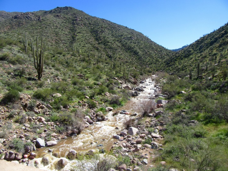
For quite a while we drove alongside the river, fairly flat and so pretty.

And finally, we ended at Theodore Roosevelt Dam. This dam was started in 1903 and finished in 1911. It was the largest stone dam in the world at the time.
Between 1989 and 1996, the dam was raised by 77 feet to accommodate increased demand and prevent flooding.
Interesting fact – a family of four uses 325, 851 gallons of water in just one year.

While we were there, we had the added excitement of watching a helicopter take off from the base of the dam.

I’m adding this photo for no good reason other than I used to love seeing Smokey the Bear on TV when I was a kid. Steve was curious about my interest (and yours) in this hard-working bare-chested ranger, but all these decades later, this friendly mascot is still warning us that “Only You Can Prevent Wildfires.”

We did not have the chance to drive over Roosevelt Lake Bridge, but it is notable for being the longest 2-lane, single-span steel arch bridge in North America. Plus, they painted it light blue to blend better with its background.

We had the option of turning around here and driving back from whence we came, or driving a loop on a divided paved highway back to Apache Junction. We chose the latter.
All in all, a memorable drive and a good lesson not to believe everything you read.
Now, we’re in Quartzite and this is an entirely different experience. So much to tell you in a few days.

VIKKI AND I drove to Canyon Lake on our 27 ‘ motorhome, hairy ride. Loved the Lost Dutchman Mine park…. Had fun shopping in Quartsite too. Brings back great memories and some scary driving.
LikeLike
That would have been a more demanding drive with Flipper, no question. We’re in Quartzite now – the season here is winding down and there is almost no shopping left to speak of.
LikeLike
Hi Ginny & Steve,
I love hearing about your adventures…keep taking the high road!
Beautiful photos, thanks for sharing.
Be safe, and keep having all the fun ❤
xo Sue
LikeLike
Sue – so good to hear from you! You’re just back from a wonderful adventure – I would love to talk to you about your experiences there.
LikeLike
More beautiful pics. You two are amazing. We are home and dealing with T’s mother who fell and broke her hip and shoulder. Our medical system leaves a lot to be desired at the moment. Cheers. Joan
LikeLike
Oh Joan – I’m so sorry to hear about that, and especially if she is not getting the care she needs. How worrisome. I’ll send you an email.
LikeLike
I’m glad you decided to do the drive. Just think what you would have missed if you hadn’t. It looks like it was well worth it!
LikeLike
Those things are almost always worth it, aren’t they? Doing the things you fear; you discover there is nothing to fear after all.
LikeLike